


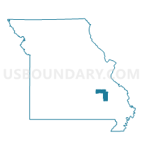
Belleview Voting District, Iron County, Missouri
About
Outline

Summary
| Unique Area Identifier | 608071 |
| Name | Belleview Voting District |
| County | Iron County |
| State | Missouri |
| Area (square miles) | 101.87 |
| Land Area (square miles) | 101.85 |
| Water Area (square miles) | 0.02 |
| % of Land Area | 99.98 |
| % of Water Area | 0.02 |
| Latitude of the Internal Point | 37.67888730 |
| Longtitude of the Internal Point | -90.84149200 |
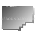
Maps


Graphs
Select a template below for downloading or customizing gragh for Belleview Voting District, Iron County, Missouri


Neighbors
Neighoring Voting District (by Name) Neighboring Voting District on the Map
- Belgrade Voting District, Washington County, MO
- Black Voting District, Reynolds County, MO
- Caledonia Voting District, Washington County, MO
- Ghermanville Voting District, Iron County, MO
- Lesterville Voting District, Reynolds County, MO
- Viburnum Voting District, Iron County, MO
Top 10 Neighboring County Subdivision (by Population) Neighboring County Subdivision on the Map
- Arcadia township, Iron County, MO (5,576)
- Belgrade township, Washington County, MO (1,226)
- Iron township, Iron County, MO (1,131)
- Bellevue township, Washington County, MO (994)
- Lesterville township, Reynolds County, MO (744)
- Black River township, Reynolds County, MO (594)
- Kaolin township, Iron County, MO (523)
Top 10 Neighboring Elementary School District (by Population) Neighboring Elementary School District on the Map
Top 10 Neighboring Unified School District (by Population) Neighboring Unified School District on the Map
- Arcadia Valley R-II School District, MO (5,908)
- Valley R-VI School District, MO (2,931)
- Lesterville R-IV School District, MO (1,295)
Top 10 Neighboring State Legislative District Lower Chamber (by Population) Neighboring State Legislative District Lower Chamber on the Map
Top 10 Neighboring State Legislative District Upper Chamber (by Population) Neighboring State Legislative District Upper Chamber on the Map
Top 10 Neighboring 111th Congressional District (by Population) Neighboring 111th Congressional District on the Map
Top 10 Neighboring Census Tract (by Population) Neighboring Census Tract on the Map
- Census Tract 4605, Washington County, MO (4,159)
- Census Tract 3801, Reynolds County, MO (3,058)
- Census Tract 9501, Iron County, MO (2,841)
Top 10 Neighboring 5-Digit ZIP Code Tabulation Area (by Population) Neighboring 5-Digit ZIP Code Tabulation Area on the Map
- 63650, MO (4,401)
- 63624, MO (3,757)
- 63622, MO (1,011)
- 63623, MO (882)
- 63631, MO (849)
- 63656, MO (531)
- 63625, MO (457)